

19 – Modeling Roadway Striping in 3D
Few things are as beautiful as good 3D visualization with high quality and accurate roadway striping. Problem is, good roadway striping can be very difficult. Join me in the 19th episode of the Civil FX Podcast as I discuss the methods I have learned to make striping a little bit more possible.
Player above not working? Either click here, or right-click and “Save Link” to download the episode.
Honest reviews are always appreciated on iTunes! (Click here)
Modeling Roadway Striping in 3D Show Notes
- One of the most difficult parts of 3D modeling in transportation
- Straight roads are easy
- Custom or unique intersections or lanes are very difficult
- Can model from CAD linework or from scratch
- You can’t just display lines on 3D model, each line needs to be given thickness and depth for rendering
- Draping is the hardest part
5 Different methods of modeling highway striping
- InfraWorks (easy, poor results)
- Sketchup
- Civil View
- Civil 3D
- Microstation/InRoads
Pro tips
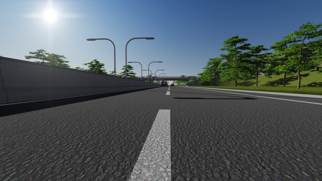
- When texturing striping, don’t just make it a white or yellow solid color. Instead, make it an asphalt texture tinted white or yellow (see image above). Good texture image files are also available for quality texturing.
- If you are working in an area that is nearly flat, consider pretending that it is perfectly flat so you don’t have to do any draping. Will save you headaches in the future!
- Typical lane striping is 8″ but 4″ is common for double yellow and 12″ is common for striped gores.
- Sometimes you can turn off the shadows if your striping isn’t perfectly against the surface of the asphalt.
Hey Sam, I never thought about adding a texture map to the color to give the linemarking a more realistic appearance. Great tip!
Nice to see such an effort for the lanes to be siengd and striped. I wonder how wide a lane will be allocated, and will it be kept clear of debris. Prior to the lane being present, I would use the right travel lane, despite a shoulder area because of the amount of sand and other debris adjacent to the barrier (at least on the inbound side). The outbound side didn’t have a shoulder nor as much debris prior. Frankly, the worse problem on this stretch is that it looks like and is driven as though it were a 50+ mph highway in contrast to the posted 35mph limit. Narrowing the road with a bike lane could help on this, but I doubt it as the road will still feel wide and fast.