

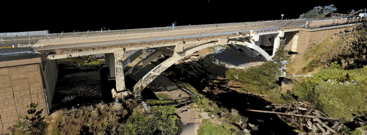
39 – 3D Laser Scanning for Highly Accurate Visualization
3D laser scanning for use with 3D modeling and visualization is possibly the most accurate form of visualization today.
Player above not working? Either click here, or right-click and “Save Link” to download the episode.
Civil FX Updates
- Lots of good response from the visualization challenge, expecting more responses this time
- The difference between an expert and a specialist
- If you find this podcast helpful, honest reviews are always appreciated – www.civilfx.com/itunes
Laser Scanning for Highly Accurate Visualization
- What is laser scan technology?
- How does it work?
- What industries is it used in?
- Why do we want it for civil projects?
- The three different types of mounted scanning devices
Processing Data
- Data capture is the first step
- The data is represented by a ‘point cloud’
- The point cloud has no real geometry
- You have to model around the point cloud data by bringing the points into a modeling program
- Recap and Cloudworx are two of the programs available to help with point cloud modeling and presentation
Final Thoughts
- While laser scanning can replace survey in certain situations, the visualization will still be representative at this point
- If photoscan technology gets good enough then there won’t be any real need for laser scan because it is much cheaper to take pictures
- This isn’t the most efficient method of capturing data for modeling